 Yahoo奇摩新聞
|山陽
- 景點+ • 2024年9月26日 下午 05:04
楓紅銀杏秋日限定大景美拍!9大廣島秋季必訪景點
廣島,日本,賞楓,銀杏 秋日到日本廣島旅行,不僅可以大啖牡蠣、螃蟹等美食,還有火紅楓葉、心形紅葉、金黃銀杏等大景可欣賞!精選廣島在地人推薦的9個秋季必訪景點,不僅能一覽美景,還能體驗渡舟、坐禪等,絕對不虛此行。
- TVBS新聞網 • 2024年8月30日 晚上 07:30
「珊珊」龜速續糾纏日本 下午出海晚間再登陸四國
這幾天一直糾纏日本的珊珊颱風,今天下午從九州出海,預估晚間會第二度,從四國登陸。珊珊颱風行進速度變慢,加上積雨雲相當活躍,九州各地都出現暴雨,目前已經造成五人死亡,兩人失蹤,多達91人受傷。
- 三立新聞網 setn.com • 2024年8月31日 下午 05:35
「珊珊」緩慢轉向四國 災情頻傳已釀6死逾百傷
記者陳采蔚/綜合報導 第10號颱風「珊珊」持續影響日本,昨(30)日晚間再度從愛媛縣今治市登陸,並朝四國、本州移動,截至目前已傳出6人死亡、110人受傷。日本氣象廳也針對東京
- 公視新聞網 • 2024年8月30日 晚上 08:28
颱風珊珊登陸日本後龜速前進 災情頻傳已釀4死逾百傷
珊珊颱風登陸日本後,儘管風雨威力稍微減弱,但移動速度慢,平均1小時10到15公里,滯留時間長,讓各地風災、雨災不斷。除了不斷有河川氾濫、要求民眾避難的警報外,也頻頻發生暴風、土石崩落,還有不少台灣、韓國飛日本的班機無法降落,只能折返。到當地下午4時為止,已有4人死亡、104人受傷,跟2人失蹤。
- EBC東森新聞 • 2024年8月31日 下午 04:18
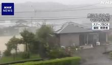
颱風「珊珊」襲日、多地雨量創紀錄!已6死、125傷
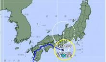
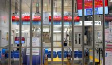
...號試圖降落福岡機場時也遭颱風吹晃機身,無法保持平衡,最後只好放棄降落,重新升空離去。 颱風造成交通大亂,日航全日空單日共取消61個航班。而東海道新幹線,東京站至名古屋站區間,自31號清晨起停駛。NHK記者安藤佳祐:「我的後方可以看到,正好有東海道山陽新幹線剪票口的地方,這個時間點拉上了鐵捲門,變成無法進站。」 珊珊預計31號晚間6點離開四國,並於9月1日清晨6點,登陸本州,雖然將減弱為,熱帶低氣壓,但9月2日仍會席捲近畿地方,預估帶來強烈風雨。
- TVBS新聞網 • 2024年8月30日 下午 12:32
「護日神山」在屋久島!珊珊結構被破壞 威力迅速減弱中
今年第10號颱風「珊珊」,登陸日本一天之後,現在威力迅速減弱。日本氣象專家表示,珊珊在登陸前,曾經過鹿兒島的屋久島,而且九州排名前八的高山都在屋久島上,所以導致珊珊的結構被破壞。儘管如此,在珊珊暴風圈外的東京、靜岡等地區,卻還是傳出災情。
- TVBS新聞網 • 2024年8月30日 上午 10:41
珊珊颱風龜速襲日 3死逾80傷 破紀錄大雨下到九月初
日本喻為最強等級的珊珊颱風,今天(29日)早上從九州的鹿兒島登陸,到今天傍晚才到九州的長崎縣,以時速15公里的速度緩慢北上,為九州和四國帶來強風大雨。登陸後颱風強度稍稍減弱,但雲雨依然活躍,在不少地方都降下破紀錄大雨,多條河流氾濫潰堤。由於速度緩慢,颱風估計週五繼續橫掃九州,到9月1日停滯近畿地方,2日往東日本前進,持續影響日本各地交通。週四日本國內航班已取消近500個班次,影響超過3萬5千人。
- 品觀點 • 2024年8月30日 上午 11:09
颱風珊珊肆虐日本九州!已4死94傷 豪雨破紀錄
颱風珊珊29日登陸日本鹿兒島縣,截至30日清晨7點,已知釀成4死、94傷、1失蹤,也為九州各地帶來破紀錄豪雨。截至29日下午6時,72小時降雨量最高值出現在大分縣佐伯市劍崎,高達597毫米。大分縣、靜岡縣共5處創當地觀測史上降雨量最高紀錄。
- 中天新聞網 • 2024年8月29日 上午 10:17
影/史上最強等級!珊珊颱風登陸九州 「JR列車全日停駛」坂本龍馬也要躲
被日本列為「史上最強等級」的珊珊颱風,台灣時間29日早上7點已於九州登陸,預計上午大分縣將籠罩在暴風圈內,當地JR列車全日停駛。而高知當地巨型「坂本龍馬」雕像也即早撤離避難。
- 台視新聞網 • 2024年8月29日 上午 09:52
恐是日本史上最強颱風! 珊珊今九州登陸39傷、1失蹤
珊珊颱風在日本時間早上8點左右登陸九州鹿兒島縣的薩摩川內市,替當地帶來強風暴雨,造成至少39人受傷、1人失蹤,目前珊珊颱風龜速朝日本前進,前氣象局長鄭明典也示警,「颱風走得慢會是大問題」。雨彈襲宮崎市
- 今日新聞NOWnews • 2024年8月29日 上午 10:53
影/珊珊颱風登陸九州 陸空交通大亂
[NOWnews今日新聞]珊珊颱風於日本當地時間29日上午8點,在鹿兒島縣薩摩川內市附近登陸,日本氣象廳向鹿兒島縣發布強風巨浪特別警報,九州多地出現豪大雨,陸空交通嚴重受阻。綜合《NHK》等日媒報導,...
- 三立新聞網 setn.com • 2024年8月29日 中午 12:20
珊珊颱風挾強大風雨襲日!陸空交通大亂 逾438航班取消
國際中心/柯美儀報導珊珊颱風於日本當地時間29日上午8點(台灣時間上午7時),在鹿兒島縣薩摩川內市附近登陸,九州多地出現豪大雨,陸空交通嚴重受阻,九州新幹線、西九州新幹線29日全線
- 新頭殼 • 2024年8月29日 上午 09:15
全台續飆高溫!中颱珊珊「迷蹤步」登陸日本估挾驚人降雨釀嚴重災情
[Newtalk新聞] 全台持續高溫炎熱,中央氣象署預測,今(29)天各地高溫普遍在33到35度,大台北及台東仍有局部36度以上高溫發生的機率,沒下雨時感受悶熱,戶外活動請多補充水分。白天起台灣各地及澎湖、金門、馬祖為多雲到晴,不過午後雷陣雨範圍稍增。另一方面,今年第10號颱風「珊珊」挾帶著驚人的風雨並緩慢北上,預估將為日本帶來嚴重災情。 氣象署說明,除了各地山區外,近山區的平地也容易有局部午後短暫雷陣雨,有局部大雨發生的機率,部分地區的降雨可能持續到晚上,中午過後外出請留意天氣變化,攜帶雨具備用;溫度方面,各地高溫普遍在33到35度,大台北及台東仍...
- 鏡週刊Mirror Media • 2024年8月29日 下午 02:50
珊珊來襲!日本九州暴雨釀災54傷1失蹤 超商急打烊、部分列車停駛
中颱「珊珊」今(29日)上午從九州南部登陸日本,颱風挾帶的強烈風雨也為當地造成嚴重災情,許多地區道路被強降雨淹沒,各地累計通報54人受傷,前一晚更傳出在鹿兒島市有一名60多歲的男子從鹿兒島港碼頭乘船後墜海失蹤。
- 今日新聞NOWnews • 2024年8月29日 下午 03:00
珊珊來襲 大阪環球影城週末特別活動恐取消
[NOWnews今日新聞]今年第10號颱風珊珊於日本當地時間29日上午8點,在鹿兒島縣薩摩川內市附近登陸,且維持強大威力持續北上。日本各地防颱如臨大敵,日本大阪環球影城(USJ)也宣布,8月31日至9...
- TVBS新聞網 • 2024年8月29日 早上 07:54
日本史上最強颱風珊珊來襲!專家示警「這3天」嚴重威脅
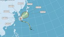
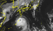
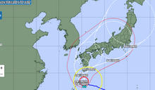
今(29)日起三天若有日本九州、四國及本州等地的行程,應密切注意中颱「珊珊」動態!專家指出,颱風「珊珊」逼近日本九州,在鹿兒島西側近海,颱風眼已漸模糊;登陸前稍減弱,登陸後則受地形破壞、強度持續減弱。今日2時「中央氣象署」的「路徑潛勢預測圖」顯示,中颱「珊珊」在日本九州西側近海,偏北逐漸轉向偏東,因導引氣流弱、且多變,移速不快、路徑不確定性加大,對日構成嚴重威脅。
- 公視新聞網 • 2024年8月29日 晚上 07:45
珊珊颱風撲日本九州已釀3死 陸空交通癱瘓、900超商停業
珊珊颱風侵襲日本夾帶強風豪雨,29日上午從鹿兒島縣登陸,不只造成九州各地風災頻傳,還傳出線性對流、豪雨導致河川氾濫。目前至少釀成3人死亡、1人失蹤,另外還有74人受傷;九州地區的3大超商共900家分店目前皆停止營業,汽車製造業者也宣布工廠停運,陸空交通則幾乎全面癱瘓。
- 品觀點 • 2024年8月28日 下午 01:00
珊珊颱風恐嚴重日本4天!連日大雨交通大亂
...苫小牧市區道路淹水,厚真町內有2戶民宅淹水,另有一處道路因土石崩落暫停通行。JR北海道已停駛127個車次列車,北海道46所學校臨時宣布停課。 在本州,靜岡縣的大雨也導致東海道新幹線27日上午及下午一度停駛。JR各公司表示,未來幾天山陽新幹線、東海道新幹線、九州新幹線等多條新幹線線路都可能出現全線或區間路段停駛情況。 日本氣象廳呼籲,西日本與東日本太平洋側地區大氣狀態十分不穩定,民眾應留意間歇激烈降雨。預測未來24小時奄美地區以及西日本到東日本的太平洋側降雨量...
- 民視 • 2024年8月28日 下午 03:02
珊珊強襲日本九州! 鹿兒島等地交通大亂、民眾急避難
即時中心/林耿郁報導中度颱風珊珊,目前直撲日本九州;日本氣象廳發布強風巨浪特別警報,要求民眾保持最高警戒;受到珊珊影響,至少有200個飛機航班遭到取消,上萬旅客受影響;新幹線與高速公路也可能停駛與封閉,近期赴日的民眾請特別注意。
- 太報 • 2024年8月28日 下午 04:50
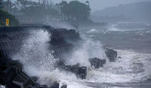
強颱珊珊襲日氣象廳罕見發「特別警報」 各地現雨勢、新幹線飛機部分取消停駛
今年第10號颱風珊珊逼近日本,暴風圈將涵蓋九州、四國及本州幾乎所有陸地,日本如臨大敵。首當其衝的九州宮崎市和鹿兒島市已發出第4級避難警戒,多條新幹線停駛,九州起降航班取消。氣象廳罕見發布特別警報,強烈呼籲民眾務必作好防颱與避難準備。
- TVBS新聞網 • 2024年8月28日 晚上 10:23
史上最強颱「珊珊」來遲!九州暴雨恐「十年一遇」災情
被日本稱為「史上最強等級」的颱風「珊珊」,因為行進速度緩慢,目前還在九州外海打轉,今天鹿兒島罕見發布「暴風巨浪特別警戒」,有70萬人已經收到避難警示通知。目前預估週五登陸九州後,一路北上,周末將影響到東京,東海道新幹線已經有部分停駛。
- 今日新聞NOWnews • 2024年8月27日 下午 04:39
珊珊颱風將登九州 日航取消今明122個航班
[NOWnews今日新聞]今年第10號颱風「珊珊」在日本九州南方海面緩步轉向,預估明(28)日轉北後將直撲九州地區,並一路貫穿日本列島,影響時間拉長,對日本帶來巨大衝擊。日本航空(JAL)下午宣布,取...
- 太報 • 2024年8月27日 下午 01:43
怪颱珊珊緩步難預測 日航取消122航班、新幹線29日起恐預防性停駛
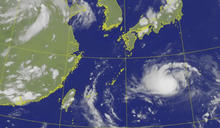
今年第10號颱風珊珊今(8/27)強度增強向西前進,同時日本奄美的部分地已壟罩在暴風圈之下。氣象廳研判,颱風將於29日後改變路徑,向北接近西日本,並有可能登陸。關於颱風路徑,氣象廳表示,有許多不確定因素,「颱風會變成『迷走型颱風』,關東地區有可能出現災害級別的大雨與暴風」。
- TVBS新聞網 • 2024年8月28日 下午 02:44
珊珊颱風路徑西修估8/29登陸九州 JR九州宣布停駛、近三百航班取消
珊珊颱風目前位於日本南方海面,以時速20公里速度朝西北西方向移動。日本氣象廳最新預測指出,珊珊颱風路徑西修,影響日本期間延後。根據預測,颱風恐於29日登陸九州南部,接著貫穿西日本,帶來狂風暴雨。由於颱風路徑改變,JR東海等也緊急調整新幹線可能停駛時間,日本航空也宣布逾百航班取消。
- 公視新聞網 • 2024年8月26日 晚上 07:47
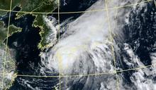
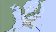
珊珊颱風威力上看強颱等級 預估路徑修正恐貫穿日本本州
今(2024)年第10號颱風珊珊,撲向日本的移動路徑,受到上空的冷心低壓影響不斷修正。到26日為止,行進方向已修正為西北西方,27日威力將可能持續發展擴大,變成強烈颱風。另外珊珊行進方向也將可能再次變更,預計行進路線將貫穿日本本州,日本各地新幹線等交通運輸,可能都將停運2到3日。
- 今日新聞NOWnews • 2024年8月26日 中午 11:56
珊珊颱風路徑超難捉摸!日本氣象廳預報再改
[NOWnews今日新聞]第10號颱風「珊珊」目前強度已達中度颱風等級,預估仍有些許增強空間,過去數日各國路徑預報雖皆顯示將朝日本而去,但路徑卻一再西偏,日本氣象廳今早的路徑預報再度將路徑西修至登陸九...
- TVBS新聞網 • 2024年8月26日 上午 10:07
珊珊颱風登陸日本前已有災情!栃木縣降破紀錄大暴雨 關東剉咧等
今年第10號颱風珊珊可能於28日從日本九州或四國地方登陸,貫穿整個日本,影響持續到30日上午。隨著珊珊颱風逐漸逼近,26日在日本西部和東部太平洋沿岸,陸續出現大暴雨並伴隨雷電。栃木縣北部出現線狀降雨帶,凌晨降下暴雨,其中鹽谷町3小時內累積雨量206毫米,創下觀測史上破紀錄豪雨,多處淹水。
- TVBS新聞網 • 2024年8月27日 晚上 09:50
珊珊颱風路徑估「登陸九州貫穿日本」 日航砍122班次、新幹線預告停駛
日本氣象廳公布珊珊颱風最新動態,珊珊颱風於今(27)日升級為「非常強烈颱風」,台灣時間上午11點位於日本奄美市以東約110公里海面,以緩慢速度朝西北西方向移動。根據氣象廳公布的最新路徑,珊珊颱風預計於28日接近奄美市後北轉,在29日至30日之間登陸九州,接著貫穿日本,對日本影響恐長達5天。
- 今日新聞NOWnews • 2024年8月25日 晚上 08:03
珊珊颱風撲日本威力恐不減弱 JR視天候停駛
[NOWnews今日新聞]日本近日受太平洋高氣壓影響,九州至東北各地下起豪雨,同時強烈颱風「珊珊」路徑可能在威力不減下直撲日本西部至東部地區,在惡劣天氣影響下,京都車站目前已有部分區域淹水,JR東海和...
- TVBS新聞網 • 2024年8月25日 晚上 06:07
日本又下「破紀錄暴雨」 京都車站淹水、新幹線一度停駛
日本氣象廳表示,今(25)日受到太平洋高氣壓影響,日本九州至東北地區天氣不穩定,各地下起豪大雨。日本氣象廳針對富山縣、新潟縣、岩手縣等地宣布「短時間大雨情報」。日本關西地區也受到暴雨襲擊,京都車站淹水,東海道新幹線部分區域也宣布暫時停駛。氣象廳指出,天氣不穩的狀況會持續到26日,呼籲民眾注意淹水、河川氾濫和土石流等災害。