 Yahoo奇摩新聞
日本東方海面
- 太報 • 11 小時前
又有熱帶低壓生成!2日內恐增強為「康芮」颱風 日本氣象廳預測路徑出爐
受到潭美颱風外圍環流及東北季風影響,台灣各地今天(10/24)天氣不穩,部分地區甚至出現豪大雨。日本氣象廳今發布颱風情報,目前太平洋海面上除了潭美颱風之外,又有熱帶性低氣壓生成,若成颱將會是今年第21號颱風「康芮」,路徑仍有待觀察。
- Yahoo奇摩(即時新聞) • 2024年10月9日 下午 03:38
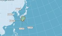
第19號颱風百里嘉生成 估朝日本東方海面移動對台無影響
中央氣象署今天(9日)發布第19號颱風生成訊息,原位於日本東南方海面的熱帶性低氣壓,於今天下午2時發展為輕度颱風,編號第19號百里嘉(國際命名:BARIJAT),預測未來往北北東朝日本東方海面移動,對台灣無直接影響。
- Yahoo奇摩(即時新聞) • 2024年9月27日 下午 03:44
颱風接力!「燕子」朝日本南方海面前進 「山陀兒」最快今晚生成9/30到10/2最近台
交通部中央氣象署今天表示,位於關島附近的熱帶性低氣壓下午增強為今年第17號颱風燕子,預計未來朝日本南方海面前進,對台灣沒有影響。位於台灣東方的熱帶性低氣壓最快今晚到明天清晨增強為輕度颱風山陀兒,最靠近台灣的時間點為9月30日到10月2日。
- 中時新聞網 • 11 小時前
又有熱帶低壓!日本氣象廳估明生成康芮颱風
菲律賓東方遠洋還有一個熱帶系統發展,日本氣象廳今天上午已將它升格為熱帶性低氣壓,預估明天(25日)增強為康芮颱風,路徑仍有不確定性,應持續觀察。
- 中天新聞網 • 2024年10月9日 下午 03:53
快訊/今年第19號颱「百里嘉」生成!朝日本海面移動、對台無影響
熱帶性低氣壓TD23在日本東南方海面徘徊,日本氣象廳9日下午宣布,該熱帶低壓已增強為今年第19號颱風「百里嘉」(BARIJAT)。台灣中央氣象署預估,百里嘉颱風將往日本海面移動,對台灣無影響。
- TVBS新聞網 • 2 天前
真夏日緊接本季最冷 日本「秋季疲勞」激增
近來天氣忽冷忽熱,要當心所謂的「秋季疲勞」。日本東京週末氣溫有如三溫暖,熱出30.1度高溫,創最晚「真夏日」紀錄;緊接著冷鋒過境,週一低溫降至11.5度,創本季最冷,三天內溫差超過20度。民眾身體跟不上氣溫變化,九月入秋以來秋季疲勞患者增加,可能出現集中力下降、食慾不振、睡眠品質低下、總覺疲勞等症狀。
- 三立新聞網 setn.com • 2024年9月25日 上午 11:14
今晚恐增強為「西馬隆」颱風!預測路徑曝光 下個颱風「燕子」離台較近
日本氣象廳資料顯示,日本南方海面新的熱帶性低氣壓生成。中央氣象署指出,最快今(25)日晚間有可能增強為颱風「西馬隆」,預估路徑曝光。
- eNews • 8 小時前
最新預估路徑出爐!雙颱將「引發藤原效應」 專家:潭美恐大迴轉「折返跑」
繼第20號颱風「潭美」登陸菲律賓呂宋島之後,本週又有一熱帶低氣壓形成,預計在未來兩天內可能增強為今年第21號颱風「康芮」。氣象粉專「台灣颱風論壇天氣特急」提醒,依據中央氣象署的最新預測路徑,颱風潭美在
- 民視 • 8 小時前
潭美「鬼之迴轉」共舞準新颱?對台影響看2關鍵
生活中心/李汶臻報導儘管於輕颱「潭美」已在菲律東部,並持續向西北移動、且距離台灣最南邊有不小距離,但受東北季風及「潭美」外圍環流共伴效應影響,台灣東北部以及東部地區將迎來豪大雨;而如今又有氣象粉專預估,若準颱風「康芮」生成,原本逐漸遠離台灣的輕颱「潭美」,恐出現詭異的大迴轉走向,且不排除出現兩颱共舞的罕見情境;至於潭美迴轉後有多靠近台灣,台灣是否被兩颱夾擊、慘淪「夾心內餡」,氣象粉專則指出將取決於這兩大關鍵。
- 中央社 • 2024年10月9日 下午 03:44
颱風百里嘉生成 朝日本東方海面移動對台無影響
(中央社記者張雄風台北9日電)中央氣象署今天下午發布颱風生成訊息,原位於日本東南方海面的熱帶性低氣壓,於今天下午2時發展為輕度颱風,為編號第19號百里嘉(國際命名:BARIJAT)。
- 今日新聞NOWnews • 4 天前
日氣象廳估潭美颱風將生成 影響路徑曝光
[NOWnews今日新聞]根據日本氣象廳最新分析,目前在菲律賓東方海面的熱帶擾動,預計在24小時內增強,也就是最快會在週一(21)發展為第20號颱風「潭美」,從目前的預測路徑來看,這個熱帶低壓有可能先...
- TVBS新聞網 • 10 小時前
潭美颱風變「大型強烈熱帶風暴」 日氣象廳曝這天最靠近台灣南部
受第20號颱風潭美外圍環流及東北季風影響,今(23日)晚間至週五迎風面地區容易有大雨或豪雨,山區及北海岸甚至有局部豪雨等級以上降雨。潭美颱風在日本時間下午6點轉為「大型強烈熱帶風暴」,日本氣象廳也公布最新颱風路徑,今、明兩天潭美颱風將通過菲律賓接著進入南海,24日可能最靠近台灣南部。
- 中廣新聞網 • 10 小時前
雙颱效應?熱帶低壓將增強為「康芮」颱風 恐牽動「潭美」戲劇性大迴轉
今年第20號颱風潭美雖然沒有登陸台灣,但外圍環流加上東北季風共伴效應,北台灣恐怕接下來幾天將面臨強風豪雨。然而前一個颱風還沒走,在關島東南北方,又有一個熱帶性低氣壓生成,今明兩天可能增強今年第21號颱
- 鏡週刊Mirror Media • 11 小時前
準颱風康芮將生成 粉專:讓潭美戲劇性大迴轉的關鍵
輕度颱風潭美登陸菲律賓後,造成當地嚴重災情,其路徑持續往西南西前進,不過從中央氣象署的預測路徑,潭美可能還會出現大迴轉,引起不少人討論。氣象粉專今(24)日po文表示,準颱風康芮即將生成,「就是讓潭美抵達越南前,戲劇性大迴轉的關鍵角色!」
- 鏡週刊Mirror Media • 11 小時前
準颱風康芮將生成 粉專:讓潭美戲劇性大迴轉的關鍵
輕度颱風潭美登陸菲律賓後,造成當地嚴重災情,其路徑持續往西南西前進,不過從中央氣象署的預測路徑,潭美可能還會出現大迴轉,引起不少人討論。氣象粉專今(24)日po文表示,準颱風康芮即將生成,「就是讓潭美抵達越南前,戲劇性大迴轉的關鍵角色!」
- 三立新聞網 setn.com • 11 小時前
康芮颱風即將形成 颱風論壇:讓潭美「戲劇性大迴轉」的關鍵角色
日本氣象廳資料顯示,菲律賓東方海面有一熱帶性低氣壓生成,中央氣象署預估未來有機會增強為今年第21號颱風「康芮」。民間氣象粉專「台灣颱風論壇|天氣特急」指出:「準康芮就是讓潭美抵達越南前,戲劇性大迴轉的關鍵角色!」
- 新頭殼 • 10 小時前
又有颱風!本周第2個颱風將生成 氣象粉專:影響潭美關鍵角色
...Newtalk新聞] 繼潭美颱風登陸菲律賓呂宋島後,本周又有熱帶低氣壓生成,預估這兩天就可能增強為今年第21號颱風「康芮」。氣象粉專「台灣颱風論壇天氣特急」提醒,準颱風康芮恐成為潭美颱風路徑戲劇性大迴轉的關鍵。 日本氣象廳今(24)日發布颱風預警資料顯示,菲律賓東方海面有一熱帶低氣壓蠢蠢欲動,目前正以緩慢速度向西北西移動,預估最快將在今日晚間至明(25)日上午發展成為今年第21號秋颱「康芮」,有機率靠近台灣。 台灣颱風論壇天氣特急粉專今日表示,隨著準康芮颱風形成,10...
- CTWANT • 2024年9月28日 下午 03:29
雙熱帶系統發展!準「山陀兒」不排除登陸 北東雨勢明顯
[周刊王CTWANT] 根據氣象署表示,熱帶性氣低壓TD21預估明日有機會增強颱風「燕子」(Jebi,韓國提供),不過發展條件不好很快會減弱,另外在台灣東方海面的低氣壓,所處環境較適合發展,將成為熱帶性低氣壓,預估周六、日增強為颱風「山陀兒」(泰國提供,水果名)。不過氣象署表示,未來要...
- 中央社 • 2024年9月27日 下午 03:31
颱風燕子生成 朝日本南方海面前進、對台無影響
(中央社記者余曉涵台北27日電)交通部中央氣象署今天表示,位於關島附近的熱帶性低氣壓下午增強為今年第17號颱風燕子,預計未來朝日本南方海面前進,對台灣沒有影響。
- 民視 • 16 小時前
東北季風遇潭美外圍環流共伴效應 東半部防「致災性」豪雨
即時中心/周欣儀報導今(24)日東北季風及颱風外圍環流影響,北部及東北部天氣稍涼,其他地區早晚亦涼;臺灣東半部、基隆北海岸、大臺北地區及恆春半島有陣雨,並有局部大雨或豪雨發生的機率,尤其基隆北海岸及大臺北山區、東北部山區、東部山區有局部豪雨等級以上降雨發生的機率,北部地區有局部短暫陣雨,中南部山區亦有零星短暫陣雨,其他地區及澎湖、金門、馬祖為多雲。
- nippon.com • 2024年9月30日 早上 08:10
日俄戰爭:20世紀首次的國家總動員戰,日本打敗大國的原因及對世界的影響
1904年,日本在明治維新下成為近代化國家,不到40年就敢與大國開戰。藉著俄羅斯入侵烏克蘭的契機,海外對日俄戰爭的關注度也逐漸提高,以下將簡明闡述這段歷史的背景、經過及其影響。
- 壹蘋新聞網 • 1 天前
潭美雨炸2縣市「越晚雨越大」 最快週五又有颱風!
【記者黃泓哲、江宜潔/綜合報導】今年第20號颱風「潭美」(TRAMI)昨日(22日)凌晨已生成,即便未來不直接觸陸侵襲,不過因受其外圍環流及東北季風雙重影響,這幾天台灣將出現明顯風雨,尤其北部、東北部地區今(23)日起至週五(25)需特別注意豪雨和強陣風狀況。中央氣象署指出,今日「霜降」越晚雨越大,而這波雨勢將以明(24)日最猛烈、直到週五白天才趨緩,且最快週五又有另一個颱風生成。
- FTNN新聞網 • 1 天前
今「霜降」降溫有感!東北季風持續增強...越晚雨越大 新颱風「康芮」最快週五生成
[FTNN新聞網]生活中心/綜合報導今(23)日是24節氣中「霜降」,由於東北季風持續增強,溫度方面,北台灣整天濕涼,氣溫介於22至25度,其他地區白天高溫28至3...
- 中天新聞網 • 2024年9月24日 中午 12:23
海面2低壓「產生藤原效應了」!鄭明典示警:恐影響台灣天氣
連日大雨讓全台多處都淹大水,不過目前鋒面北移雨勢漸緩。前氣象局長鄭明典po出衛星雲圖指出,台灣附近海面上有兩個低壓,目前已產生藤原效應,可能影響台灣未來的天氣。
- 太報 • 2 天前
「霜降」今雨勢愈晚愈強 潭美颱風外圍環流季風輻合防大雨
今天(10/23)是24節氣的「霜降」,東北季風持續增強,潭美颱風外圍環流相輻合後,今晚起到周五在迎風面地區可能有明顯雨勢,氣象署也針對台北市、宜蘭縣發布大雨特報;此外,菲律賓東方還有一個熱帶系統發展,可能生成第21號颱風「康芮」。
- 品觀點 • 1 天前
潭美颱風挾東北季風!周四起防強風豪雨
中央氣象署預報員黃恩鴻指出,目前輕颱潭美位於鵝鑾鼻南南東方約1000公里海面上,持續朝呂宋島前進。雖然潭美結構鬆散,但暴風圈風力強勁,預估暴風半徑將從目前的150公里,於23日下半天增加至280公里。
- 民視 • 2024年9月14日 上午 09:34
輕颱「貝碧佳」今將通過琉球海面 今北部、東北部慎防雷雨
即時中心/周欣儀報導氣象署說明,今(14)日水氣偏多,臺灣北部、東北部地區及澎湖、馬祖有局部短暫陣雨或雷雨,並有局部大雨發生的機率,其他地區及金門為多雲到晴,午後各地有局部短暫雷陣雨,中南部地區有局部大雨發生的機率,清晨至上午南部地區亦有零星短暫陣雨。
- 中天新聞網 • 2024年9月15日 下午 02:33
中颱貝碧佳奔向大陸!日本氣象廳預測「今晚2熱低壓將生成」
中颱「貝碧佳」預計週一登陸大陸上海一帶,對於台灣的天氣沒有直接影響。日本氣象廳今(15日)分析,預計今天晚上可能有2個熱帶性低氣壓將生成,很可能增強為颱風。
- 中天新聞網 • 3 天前
潭美颱風最快今生成! 日氣象廳預測「對台影響」時間點曝光
目前在菲律賓東方海面上的熱帶低壓TD24,最快今天(10/21)會發展為颱風「潭美」。日本氣象廳和我中央氣象署對其路徑預測不同,對台灣的影響還有變數。
- 中天新聞網 • 2 天前
潭美颱風挾雨彈開轟!北部、東部豪雨炸到發紫 新颱「康芮」對台影響曝
2縣市大雨特報!潭美颱風朝西北西移動,將穿越菲律賓呂宋島北部,氣象署提醒,週三(23日)晚間至週五(25日)對台灣有顯著的風雨影響。另外,菲律賓東方海面還有熱帶系統發展,不排除於25日形成颱風。